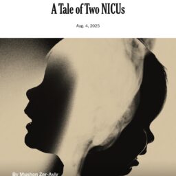
Launching: MapFutur.es — a map of Future Screenshots

MapFutur.es is an online map that gathers fragments of imagined futures: “future screenshots”—speculative visions shaped as tweets, chats, maps, protest signs, or headlines. They’re not predictions. They’re provocations. They ask: what might still be possible? What futures are already taking shape in how we grieve, resist, and imagine? The Futures Map is nonlinear. It’s organized … Continue reading Launching: MapFutur.es — a map of Future Screenshots

On Future Screenshots and Political Imagination [article]

In the aftermath of October 7th, the future between the river and the sea has felt increasingly illegible—narrowed by grief, fear, and polarized certainties. Future Screenshots is a response to that closing horizon. It’s an invitation to imagine again. The project collects speculative glimpses into possible futures—captured as if from social media, protest signs, maps, … Continue reading On Future Screenshots and Political Imagination [article]

No exit — every feed is a traffic jam @ UX Collective

Infinitely scrolling down alternative feeds is getting us nowhere. To reinvent social media, we must imagine new socials. In the past few years, we’ve been experiencing a rough fallout from our prolonged honeymoon with social media. The imminent decline of Facebook and the chaos in Twitter opened the appetite for something different. Many of us … Continue reading No exit — every feed is a traffic jam @ UX Collective

Towards Teleportation—Wayfinding Maps & Mapfinding Ways @ Re:publica 2023

I was excited to return to Re:publica to talk about why I think we’ve been optimizing technology towards teleportation. Check out the video documentation and the talk description: Your GPS app directs you, turn-by-turn, on the quickest route from A to B. At the same time, it also defines time as the single, non-exchangeable currency … Continue reading Towards Teleportation—Wayfinding Maps & Mapfinding Ways @ Re:publica 2023

I designed a map of my country, you won’t believe what happened next…

The Tel Aviv-Jaffa municipality hired me to design a map of Israel for every one of its more than 2000 classes in the city. The news leaked even before September 1st and the Ministry of Education (?) rushed to ban the map for attempting to teach our kids about the complexity of our borders. Admirably, … Continue reading I designed a map of my country, you won’t believe what happened next…